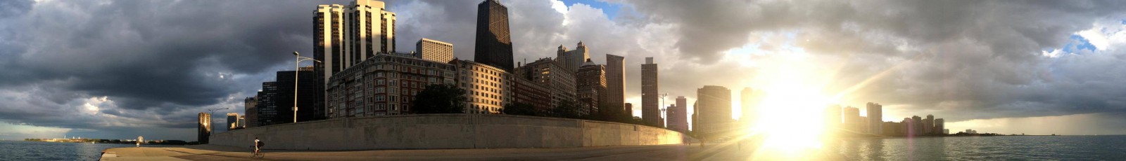
Over the past two weeks I got to travel the country. I drove from Chicago, Illinois to Seattle, Washington – via Kansas City, MO, Wichita, KS, Denver/Longmont, CO, Salt Lake City, UT, Reno, NV, San Francisco, CA, and Portland, OR. I got to see a wide variety of transit systems and road networks, and learn a bit from different cities. Wichita was the first place I spent time – and I stayed with my friend Jimmy there for about 4 days. Wichita doesn’t have suffixes for their roads. They simply name their roads things like Oliver, or Hydraulic. There is no St., Ave., Rd., Blvd. suffixes, they simply are a name (except where there are numbered streets, 21st st, or 13th st., where I got off the expressway). To a resident, this is second nature, they all have it figured out and it works just fine for them, but to an outsider, driving down their expressways, when I see a sign that says Hydraulic, this exit, I expect that to mean a town named hydraulic, not a street that runs roughly parallel to the freeway. (Jimmy lived off Oliver – which also runs through his University). I thought this was an interesting approach to naming roads.
My next stop was Longmont, Colorado. Longmont is a town about 30-35 minutes in clear traffic North of Denver, and about 10 minutes from Boulder. Longmont is very suburban, and as I learned it is the site of heavy investment by the tech industry. They have city streets that run at 40-50 mph, and bikes are allowed on the freeways there (though in the shoulder). Bikes actually utilized their allowance on the freeway, much to my surprise. There were also bike lanes on pretty much all the city-streets, even the ones running at 50 – and plenty of people used them, and people were walking as well. There was also a new urbanist development there, as well as an abandoned shopping mall. The new Urbanist development could apparently sell homes miles and miles from the city at $500-600,000 and sold as fast as it was built. there’s shops in it, sidewalks, and it seemed like a really nice place. It did have odd street names though – like, Neon Forest Circle, and Tenacity Drive.
Next on the hit-list was Salt Lake City, Utah. I had flown over Salt Lake City two weeks prior on my way home from Vegas, and seen a street with four sets of dotted yellow lines down the middle of it from my airplane. So I naturally had to drive down and see what was going on with that street. Salt Lake City is another city with a strange way of labeling streets. They name their streets with addresses. Their names include 5400 S. (where the yellow lines were), 600 S. (where I got off downtown), 4300 S. (where I got off thinking it was the yellow line street), etc. running East-West. North-South streets seemed to have normal names in most places. So, on my way to 5400 S. I drove on a 6 lane city street, then another 6-lane city street, and when I got to 5400 S., it was 7 lanes wide. Mind, this is 5 miles south of Downtown, running East-West (so not to or particularly near Downtown). The plethora of yellow lines I found out, were there because 3 lanes in each direction, apparently doesn’t cut it at rush hour in one direction, so the street can be reconfigured on the fly to have 4 lanes in one direction, a turn lane, and 2 in the other, as well as the standard 3-1-3. It is reconfigured using light bridges over the road indicating the use of each lane (green arrows indicate open lane moving straight, turn arrows indicate where the two-way turn lane is, and X means do not travel this direction in this lane).
After seeing this, I drove downtown to find somewhere to eat. I got off of I-15/80 and was dumped onto a 7-lane One-way street. I have never seen a 7-lane one-way city street in my life.
The most I’ve ever seen if 5, the most I’ve driven on is 4. I’ve driven on freeways with 8 or 9 lanes in each direction (I-5 through Tukwila, WA/405/518/599 interchange). I was somewhat confused, and decided I needed to go left, after having been dumped into the right lane of the “street”. So I just went off at an angle across the street, and turned left, and headed for a Denny’s, which naturally was on a 7-lane one-way going the other direction, and on the opposite side, so I just turned across all lanes and got off to go eat. I was pretty amazed with how wide the roads are in Salt Lake, and how dead the place was at like Sunset. I’m used to Chicago and Seattle, which really don’t die until well after sundown.
I then drove to San Francisco (or to be more specific – Palo Alto). Palo Alto is nice, though there seem to be freeways/highways criss-crossing the entire Bay area all over the place. I-80 uses 7 of 9 X80 designations in California, all of which are in the Bay Area (280, 380, 580, 680, 780, 880, 980). There’s two large freeways up each side of the bay from San Jose to San Francisco on the West Bayshore(280, and US 101), and from San Jose to Oakland on the East Bayshore (880, 580 / 680). There are also 4 bridges from the San Francisco Peninsula to other places (Dumbarton Bridge, San Mateo Bridge, San Francisco-Oakland Bay Bridge, and the Golden Gate). I got to drive over every one of the bridges. My initial entrance took me over the Bay Bridge, which Perhaps wasn’t the best choice on Memorial Day – I waited in line to pay the toll for 1.5 hours and it took me another .5 hours to cross the bay. 2 hours of sitting in the hot East Bay sun in traffic burnt my left arm to a crisp. All of the bridges cost $5 to enter San Francisco, and are free to leave San Francisco. The toll did not seem to hem in demand enough to prevent congestion, clearly it could use raising on holidays.
Once I had settled at my friend Tosh’s uh.. room, I began to commute into the city each day for a week to explore and enjoy the city. Commuting to San Francisco is very easy from Palo Alto, from Tosh’s room we walked about 15 minutes to a caltrain station, which came every 15 ish minutes at rush hour, to every hour in the evening until midnight. At rush hour some trains were titled “baby bullet” meaning they stopped at only about 5 or 6 of the ~35-40 stations on the line. Fortunately for me, Palo Alto, and Millbrae were both stops on the Baby Bullet, meaning I was lucky enough a couple times to have my ride time into/out of the city cut in half by the express train. On CalTrain I had two options for exiting to get to Downtown S.F. I could get off at Millbrae, and transfer to BART which ran me straight into the Market St. Double Decker Subway, or I could take Caltrain all the way to San Francisco Station, and take either the T-Third St. Muni Metro Line or the N-Judah Muni Metro Line into the Market St. Subway. (Or of course I could walk from S.F. Station). San Francisco has an amazing transit system in terms of span of service, frequency of service, and quality of service, but their way finding needs some help. This is the single thing that CTA does well, and frankly, CTA does it perfectly. All CTA trains and busses have automatic announcements of every single stop on each line, All train lines are very clearly marked by large stations and colored lines. All bus stops have a large legible, Consistent, clear sign indicating where the bus will stop, what bus will stop there, and usually the span of service and a basic route map. San Francisco on the other hand, puts spray paint on whatever pole happens to be nearby for most of their bus stops. 
They also have about 5 transit agencies providing service into downtown (Golden Gate Transit, San Mateo Transit, AC Transit, West CAT, BART, and the San Francisco Municipal Transportation Agency. We quickly found out that google is actually useless for transit directions in San Francisco because it fails to indicate which transit agency it wants you to take, and for example, Google told us to take the 10 bus from 2nd/Mission to the Presidio. We naturally assumed that this meant we were to take Muni(SFMTA) Route 10, later we learned that google meant Golden Gate Route 10, and their stop was not marked at 2nd and mission at all. We eventually (through asking many different bus drivers) found out that the 45 would get us to the presidio and went to get on the 45 – this is where we discovered that some bus stops are simply spray-paint on a pole. we were wandering around on 4th st., and came across a large pole with lots of bus numbers on it – a bus stop…. But, once we were aware that this is how S.F.M.T.A. does their bus stops, we no longer had a problem finding bus stops. We took the 45, a trolleybus that goes through chinatown, in a tunnel on stockton, under the height of the hill that crosses stockton, and then up what felt like a cliff on union st., twice(two hills). Eventually, after a very exciting, and somewhat terrifying (due to the hills) bus ride, we made it to the presidio. Later at a gift shop I bought a transit map and didn’t use google to route myself again while I was in San Francisco.
When we left the presidio, we took a bus that went down Park Presidio Drive – which becomes a boulevard through Richmond. San Francisco does this really cool thing with their boulevards – they hide their wider streets from the city. They have a side street along the buildings, with a large (80ish foot) heavily planted median, then the highway (3 lanes ea. direction), then another heavily planted median, another side street, and the city. So when on the boulevard, you’d never know you were in a large city if there weren’t intersections. And in the city, you’d never know there was a highway there. It is a really nice livability feature going on there.
San Francisco seems to have bike lanes all over the city – not everywhere, but in a lot of places, and they use colored paint on their roadways more than say, Chicago or Seattle do. There’s green paint all over for bike lanes, and there’s red paint for bus/transit lanes in some parts of the city, which is pretty cool looking, and I think it helps identify more clearly to drivers where they can and cannot drive. And then there is Market Street, which is not at all clear where one can drive. I made the mistake of trying to drive it at night too – haha. the signage cannot begin to describe what is going on on that street. The F-Market & Wharves line runs down the street, there’s a ton of bus lines, there’s F-train stations in between the two lanes in each direction (meaning it looks like this: SB Lane, F Market Station, SB Lane, NB Lane, F Market Station, NB Lane. It’s a mess, and not a street really for driving on at all. IT is an INCREDIBLE transit corridor however.
On Deck one – ground level the F Market/Wharves line – with about 10 bus lines runs, and some bikes, private cars and cabs.
On Deck 2 (underground level 1) Runs the Muni-Metro Subway (Lines T, J, K, L, M, N).
On Deck 3 (Underground level 2) runs the BART Subway (Destinations: Fremont, Dublin/Pleasanton, Pittsburg/BayPoint, Richmond(not the city district, a suburb…), Daly City, SFO, and Millbrae). While I didn’t really ride the BART system in the East Bay, the only part of the entire rail system on the San Francisco side I did not ride was the M-OceanView Line of the Muni Metro, and the California, and the Powell-Mason Cable Car lines. I rode the T-Third/Sunnydale, J-Church, K-Ingleside, L-Taraval, N-Judah, F-Market/Wharves, Powell-Hyde Cable Car, and BART from Millbrae through The Embarcadero (and on to Rockridge one morning in East Bay). I got to see tons of the city, and riding the rails and busses was a super easy way to see it. San Francisco has a single fare card for all of its transit agencies, which makes it really easy to get around. You just buy a clipper card, put money on it, and Go. Muni is $2 per 90 minutes, CalTrain and BART are distance based (so you have to tap the card when you leave as well as when you enter). Muni busses and trains allow you to enter through all doors (which is not the case for CTA busses, and also not the case for Boston’s green line(which is exactly like the Muni-Metro (light Rail) system). Muni also has really cool displays in their downtown Stations (market St. Subway) that display all trains on the line, where they are, and the times for the next train on each line to the station you are standing in. 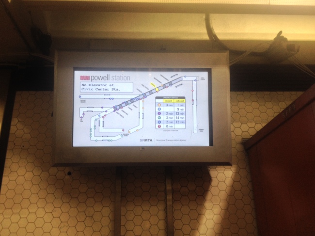
Muni has really odd light rail stops outside of the subway though, many of the stops the train just dumps you into the street. All stops outside the subway are Flag-stops (pull cord to stop – or be standing on the street visible to the train driver – train does not stop at every station/stop if it doesn’t have to).
All-in-all, getting around San Francisco spontaneously was very very easy. I carried a Bus/LightRail map with me, and a caltrain timetable and easily got around the city without a second thought really. The two coolest lines I took in the city were the F-Market & Wharves Line, and the Powell-Hyde Cable Car. The F-Line runs from Castro/Market to Fisherman’s Wharf via Market, and the Embarcadero. Its fleet consists of old restored streetcars from around the world (though mostly from the U.S.). The cars are mostly from around the ‘30s and ‘40s. They’re the PCC cars mostly, with some that are other and older designs as well. The PCCs are painted in the livery of the original owner of the car (for instance there was a car painted in the old CTA livery), making the F-line basically a living, working museum of streetcars. 

Combined with the legitimate railway museum in the middle of the line right at a stop, and you get one hell of a kick-ass streetcar experience. The trains come every 1-15 minutes, so they make getting around on The Embarcadero and Market Streets really easy. The Powell & Hyde Streets Cable Car was also pretty awesome, its a restored cable car from god only knows how long ago, and it has a grip man, and a fare collector on it, and it just rumbles right up the side of the San Fran Cliffs (well, hills, but they are almost cliffs). It was also surprisingly fast. Faster than the 45 bus even (it did have its own lanes on the really steep hills).

Muni and BART need to address some of their signage, and stop announcements and what not, but other than that, they are together with Caltrain the easiest transit systems to use and get where you’re going that I’ve ever tried to understand, and use. They’re well maintained, giving me the impression that San Francisco has unlimited money for transit. The fact that they are currently building a 1.5 billion dollar subway reinforces that perception. It was enlightening to see a city so easy to get around on trains and busses in. Apparently I timed my trip well though because Monday Muni drivers decided to have a sick-out, where they all took sick days at once to protest their new pay contract proposal… Apparently transit in the city was chaos – with busses coming every 50 minutes that should have been coming every 10. Sigh.
I will get back to my series on why busses are good soon – hopefully this week. I took a couple weeks off for my travels!
